All questions
Question 1
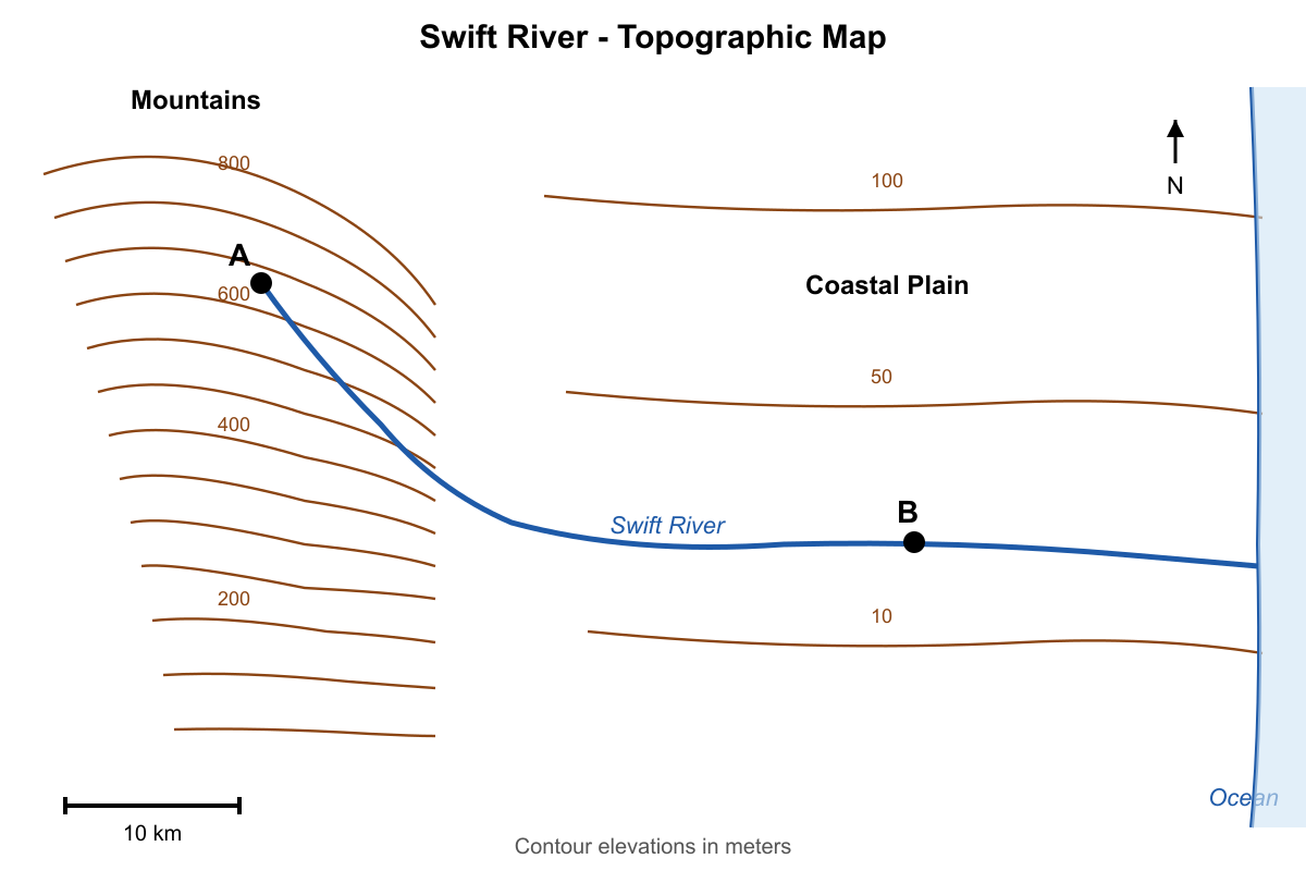
How does the gradient of the Swift River change as it flows from its source in the mountains (Point A) to the coastal plain (Point B)?
- The gradient is constant along the entire length of the river.
- The gradient is steepest near the coastal plain and gentlest in the mountains.
- The gradient generally decreases as the river flows from the mountains to the plain. (correct answer)
- The gradient generally increases as the river flows from the mountains to the plain.
Explanation: The correct answer is C. The gradient of a river is its slope. By examining the map, one can see that near the source at Point A in the mountains, the contour lines are very close together, indicating a steep slope (high gradient). As the river flows towards the coastal plain at Point B, the contour lines become much more widely spaced, indicating a gentle slope (low gradient). This pattern of a decreasing gradient from source to mouth is typical for most river systems.
A is incorrect because the contour spacing clearly changes. B and D are incorrect as they describe the opposite of the observed pattern.
Question 2
An observer is standing at point X on the side of Titan Hill. Using the compass rose and the topographic map, determine the aspect of the slope at point X. The slope at this point primarily faces which direction?
- Northwest
- Northeast
- Southwest
- Southeast (correct answer)
Explanation: The correct answer is D. Slope aspect is the direction that the slope faces, which is the direction of the steepest descent, perpendicular to the contour lines. At point X, the contour lines run roughly from southwest to northeast. The elevation decreases as you move away from the peak of Titan Hill. Drawing a line from point X perpendicular to the local contour lines in the downhill direction points towards the southeast.
A is incorrect; this direction is generally uphill from point X. B is incorrect; this direction is roughly parallel to the contour lines, indicating little to no change in elevation. C is incorrect; this is also roughly parallel to the contour lines.
Question 3
The contour pattern at location Z on the map represents a steep cliff or rock face. What is the geologic term for such a feature?
- A floodplain
- An escarpment (correct answer)
- An alluvial fan
- A drumlin
Explanation: The correct answer is B. An escarpment is a long, steep slope or cliff at the edge of a plateau or separating areas of land at different heights. On a topographic map, this is represented by contour lines that are extremely close together, sometimes even appearing to merge. The pattern at Z fits this description.
A is incorrect; a floodplain is a flat area alongside a river, represented by very widely spaced contours. C is incorrect; an alluvial fan is a fan-shaped deposit of sediment at the base of a mountain, which has a distinct convex, bulging contour pattern. D is incorrect; a drumlin is an elongated hill formed by glacial ice, which would appear as an oval shape on a topographic map.
Question 4
The map shows a volcanic crater. The contour interval is 20 meters. What is the lowest possible elevation at the bottom of the depression (point Z)?
- 1341 meters (correct answer)
- 1360 meters
- 1379 meters
- 1400 meters
Explanation: The correct answer is A. Hachured contour lines indicate a depression. The rule is that the first hachured line has the same elevation as the last regular contour line crossed. Here, the last regular contour is 1400m. Therefore, the first hachured line is also 1400m. Since the contour interval is 20m, the next hachured line inward represents a 20m decrease in elevation, making it 1380m. The next one is 1360m. Point Z is inside the 1360m hachured contour line. This means its elevation must be lower than 1360m but higher than the next hachured line would be (1340m). The lowest possible elevation is therefore just above 1340 m, so 1341 m is a possible value from the choices.
B is incorrect because Z is inside the 1360m contour, meaning it must be lower. C is incorrect; it falls between the 1380m and 1360m lines. D is incorrect as it is the elevation of the crater rim.
Question 5
Examine the topographic map provided. The elevations are given in feet. What is the contour interval of this map?
- 10 feet
- 20 feet (correct answer)
- 40 feet
- 100 feet
Explanation: The correct answer is B. To find the contour interval, locate two labeled index contours and count the number of contour lines between them. The map shows index contours at 800 feet and 900 feet. The elevation difference between them is 100 feet. There are four unlabeled contour lines between the 800-foot and 900-foot lines. This means there are five intervals in total between them (800 to line 1, line 1 to 2, 2 to 3, 3 to 4, 4 to 900). Therefore, the contour interval is the total elevation change divided by the number of intervals: 100 feet / 5 intervals = 20 feet per interval.
A is incorrect; if the interval were 10 feet, there would be 9 lines between the index contours. C is incorrect; if the interval were 40 feet, there would be only one or two lines between them. D is incorrect; 100 feet is the difference between the two index contours, not the interval between successive contours.
Question 6
The graph shows a topographic profile between two points, X and Y. The profile was created from a standard topographic map. Assuming the vertical change between each 'step' on the profile corresponds to crossing one contour line, what was the contour interval of the original map?
- 5 meters
- 10 meters (correct answer)
- 20 meters
- 50 meters
Explanation: The correct answer is B. The y-axis of the profile shows elevation in meters. Let's find a large, clear change in elevation and count the 'steps' or contour crossings. The profile climbs from 150 m to a peak at 200 m. The total elevation change is 200 m - 150 m = 50 m. In that span, the profile line clearly crosses 5 distinct intervals (from 150 to 160, 160 to 170, 170 to 180, 180 to 190, and 190 to 200). Therefore, the contour interval is the total elevation change divided by the number of intervals: 50 m / 5 intervals = 10 meters.
A, C, and D would result from miscounting the number of intervals or misreading the elevations on the y-axis.
Question 7
A hiker is planning a trip and considers four different trails (A, B, C, D) shown on the map. The hiker wants a trail that starts with a long, gentle ascent, crosses a narrow ridge, and then proceeds with a very steep descent. Which trail best matches this description?
- Trail A
- Trail B (correct answer)
- Trail C
- Trail D
Explanation: The correct answer is B. Trail B begins by crossing contour lines that are widely spaced, indicating a gentle ascent. It then crosses a narrow ridge where the contour lines are close together and form a crest. After the ridge, the trail descends a slope where the contour lines are extremely close together, signifying a very steep descent. This perfectly matches the hiker's desired route.
A is incorrect; it follows a valley floor with very little elevation change. C is incorrect; it is a continuously steep ascent. D is incorrect; it represents the opposite of the description—a steep ascent followed by a gentle descent.
Question 8
The topographic map displays a series of long, parallel ridges separated by narrow valleys. This distinctive landscape pattern, known as a trellis drainage pattern, is most likely the result of which underlying geologic condition?
- A flat-lying layer of resistant volcanic rock, such as basalt.
- A geologic dome with uplifted rock layers that have been eroded.
- Folded layers of sedimentary rock with differing resistance to erosion. (correct answer)
- A relatively uniform and uneroded granitic batholith.
Explanation: The correct answer is C. A trellis drainage pattern, which creates parallel ridges and valleys, is characteristic of regions with folded sedimentary rock layers (like anticlines and synclines). The more resistant rock layers (like sandstone) form the ridges, while the less resistant layers (like shale) are eroded away to form the valleys. This underlying structure directly controls the topography.
A is incorrect; a flat layer of basalt would form a plateau or mesa, not parallel ridges. B is incorrect; a dome would create a circular or radial drainage pattern. D is incorrect; a uniform granite batholith would likely result in a dendritic drainage pattern with no strong linear trend.
Question 9
The map shows a coastal area. If global sea level were to rise by 20 meters, what would be the most significant change to the geography of the area shown?
- The entire area shown on the map would be submerged.
- A new, large island would form where the 40-meter hill is currently.
- Tidal Bay would become a freshwater lake, cut off from the sea.
- Lookout Point peninsula would become a small island, separated from the mainland. (correct answer)
Explanation: The correct answer is D. A 20-meter rise in sea level means the new coastline will be the current 20-meter contour line. We need to trace this line to see its effect. The Lookout Point peninsula is connected to the mainland by a narrow strip of land, or isthmus, that has elevations between 10 and 20 meters. If the sea level rises to 20 meters, this isthmus will be flooded, separating the higher ground of Lookout Point from the mainland and turning it into an island.
A is incorrect, as land above 20 meters would remain. B is incorrect; hills would not form, they would shrink or be submerged. C is incorrect; the bay would expand, not be cut off.