2nd Grade Science : 2nd Grade Science
Study concepts, example questions & explanations for 2nd Grade Science


All 2nd Grade Science Resources
Example Questions
Example Question #1 : Compare Ways To Prevent Wind/Water From Changing Land Shape
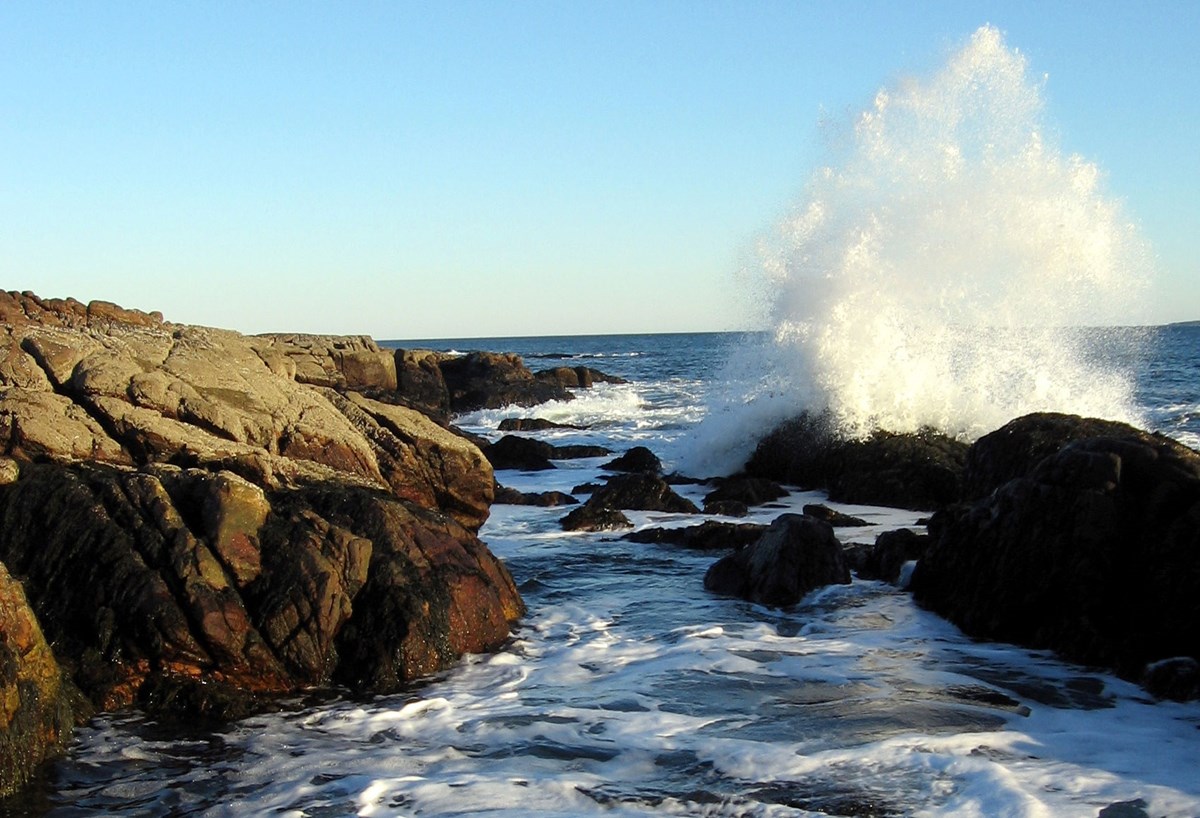
What caused erosion and the changes to the land to create this landform?
Wind and water
Vegetation and wind
Erosion did not create this landform.
Water and vegetation
Wind and water
This cliffside was formed by years and years of wind and water pushing through the ground and blowing against the sides. Erosion is the movement of broken down Earth to new places, and that is what the ocean and wind in this area have done. The water smashes into the cliffside, cutting a path while the wind blows tiny particles of soil and sand into the walls breaking it away slowly and moving it to new places. Many times humans get involved and try to prevent wind and water from damaging areas.
Example Question #44 : Earth And Space Science


There have been changes to the shoreline over the years, but then it changed back.
There have been changes to the shoreline over the years.
There have been no changes to the shoreline over the years.
Scientists cannot learn anything from these photos of the shoreline.
There have been changes to the shoreline over the years.
These aerial photos allow scientists to make comparisons of the same area over time to look for changes or similarities. In these photos, scientists could see that the shoreline has changed over the years. There is a reduction in the land visible, and more of it is underwater. The coastline has receded and become more narrow.
Example Question #45 : Earth And Space Science
In what way(s) can you represent the shapes and kinds of water in an area in a realistic way?
Take pictures of a swimming pool and describe it as a local lake
Draw a picture, create a map, or build a model
You cannot make a representation of the shape or kinds of water in an area
Create a fountain to display water in your home
Draw a picture, create a map, or build a model
Each body of water is unique and can be represented visually. The most reasonable and realistic ways to represent these bodies of water would be by drawing a picture, creating a map, or building a model. Using a model can bring in another level of detail by adding in actual water. A map and drawing will give readers a chance to see how the water is shaped and surrounded by land.
Example Question #2 : Use A Model To Represent The Shapes Of Water In An Area
Maps show where things are located, but you cannot map the shapes and kinds of water in an area.
False
True
False
This statement is untrue or false. Maps are a perfect way to show the shapes and kinds of water that are in an area. By mapping, a body of water, people can see the shape, size, depth, and how the surrounding land is shaped as well.
Example Question #46 : Earth And Space Science
Naomi's class is creating models to represent the shapes of water in different areas. She was assigned glaciers.
Which material would be the best to use to represent a glacier?
Steam
Ice cubes
Cup of water
A glacier cannot be modeled
Ice cubes
The best material to select would be the ice cubes. Glaciers are a solid made of frozen water like ice cubes. The ice cubes could be stacked or chipped into the shape of a specific glacier if needed.
Example Question #47 : Earth And Space Science
Patricia spent hours making a beautiful model of a local Canadian lake. It was complete with sand, grass, and was the same shape. She reread the instructions and realized it was supposed to be a model of the lake in winter!
What can Patricia do to her model to represent wintertime?
Put it in the freezer to turn the water to ice
Add waves, umbrellas, and beach chairs to the model
There is no way to fix the project now
Add polar bears and penguins to the shore
Put it in the freezer to turn the water to ice
Patricia needs to take her model from its current state to representing the wintertime. Patricia can put the model in the freezer to create ice instead of liquid water. In the winter, the lake could freeze over and become solid. These changes would make the lake appear to be in cold weather.
Example Question #48 : Earth And Space Science
What is a characteristic of Earth’s bodies of water?
They are all made of saltwater.
They each have the same animals and plants in them.
They are each unique and have their own shape.
They are all identical to each other.
They are each unique and have their own shape.
A characteristic of Earth's bodies of water is that they are all unique and have their own shape. No two bodies of water are the same. They are all shaped differently, have different plants and animals, varying depths, and are located across the globe.
Example Question #49 : Earth And Space Science
In what way(s) can you represent the shapes and kinds of water in an area in a realistic way?
Make a model
Create a map
Draw a picture
All of the answer choices are correct
All of the answer choices are correct
Each body of water is unique and can be represented visually. The most reasonable and realistic ways to represent these bodies of water would be by drawing a picture, creating a map, or building a model. Using a model can bring in another level of detail by adding in actual water. A map and drawing will give readers a chance to see how the water is shaped and surrounded by land. All of the listed answer choices would be good ways to represent bodies of water.
Example Question #51 : Earth And Space Science
Many people will model the shape of a body of water with a map. A map shows people where the water is and what it looks like from above.
True
False
True
Maps are a perfect way to show the shapes and kinds of water that are in an area. By mapping, a body of water, people can see the shape, size, depth, and how the surrounding land is shaped as well. Making a map is a clear way to demonstrate details about a body of water.
Example Question #1 : Use A Model To Represent The Shapes Of Water In An Area
Reba has to make a model of bodies of water in her area. Her teacher tells her she can pick one of the local lakes, ponds, or the ocean shore. She also gets modeling clay, water, and a tray. Which item should she choose to help her make her model accurate?
A drawing a classmate created
A photo of a family fishing
A detailed local map
A globe
A detailed local map
Maps are a perfect way to show the shapes and kinds of water that are in an area. By mapping, a body of water, people can see the shape, size, depth, and how the surrounding land is shaped as well. If the map is local and, detailed Reba can use this as a plan to follow when making the model.


All 2nd Grade Science Resources